By Councillor Charles Jago, updated 26 January 2026
Summary of changes
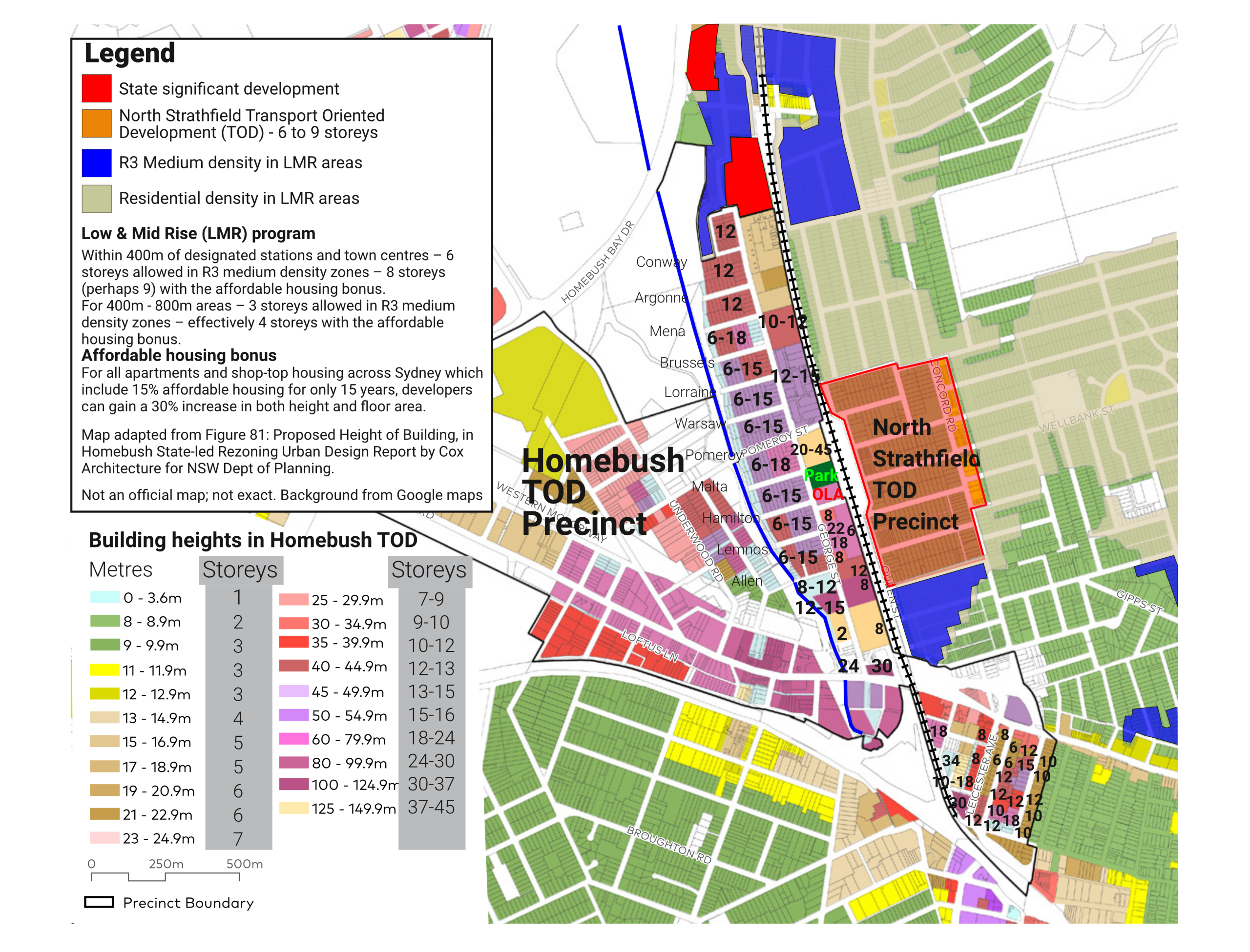
The Homebush TOD precinct was rezoned in November 2024, with extreme heights up to 50 storeys, as shown on the map above. The North Strathfield TOD was rezoned at the same time, with heights of up to six storeys plus another two (sometimes another three) storeys due to the affordable housing bonus.
But other R3 medium density areas (shown in solid blue on the map) which are not in a Transport Oriented Development (TOD) precinct have effectively been given the same the same increased heights as the North Strathfield TOD, due to the Low and Mid Rise program.
Impact of Homebush Precinct TOD
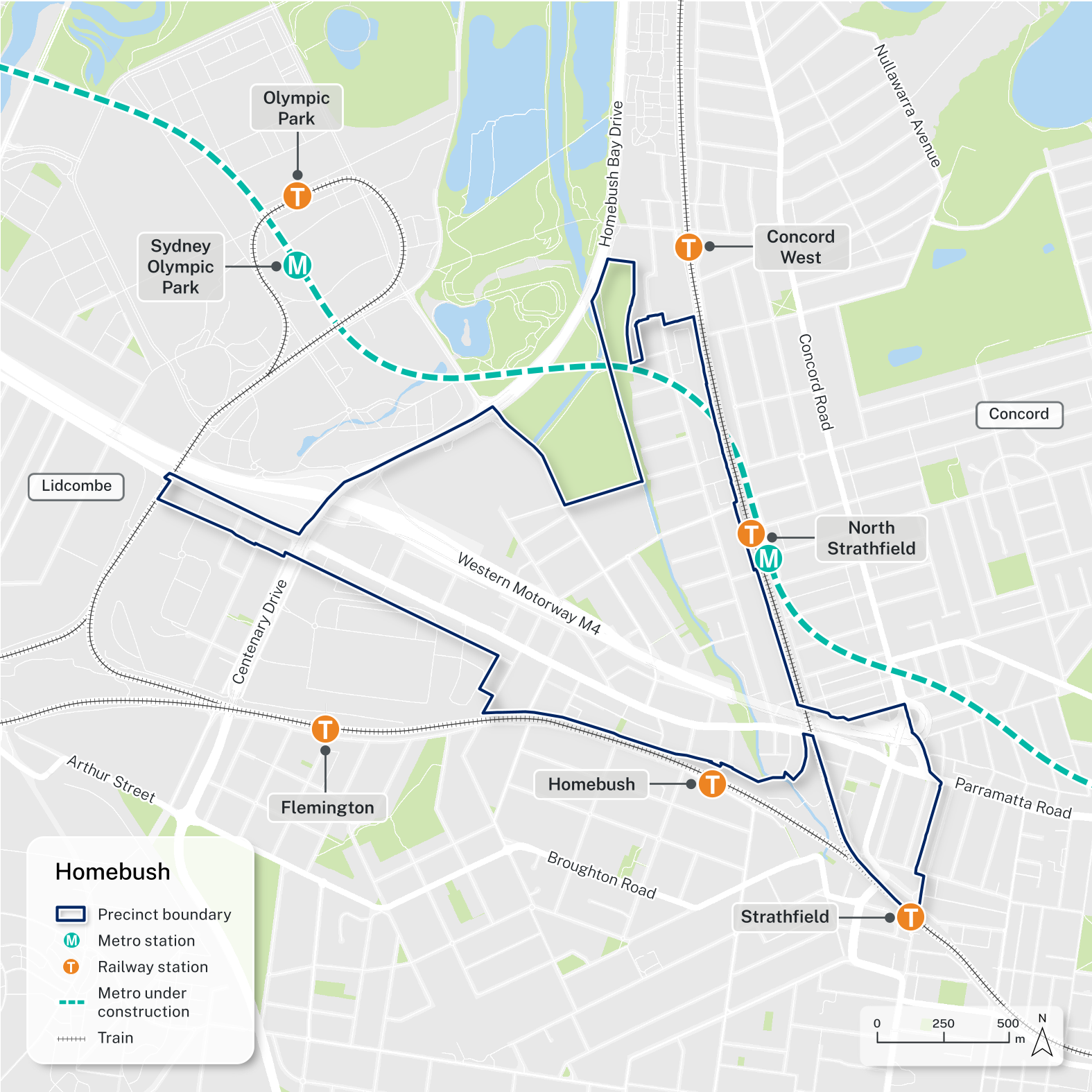
All of North Strathfield on the Homebush (western) side of the train line – from Parramatta Road up to Rothwell Avenue – is now part of the Homebush Precinct TOD (Transport Oriented Development program), with heights up to 50 storeys finalised with new zoning in late November 2024. The numbers on the map show the maximum building height for each block as finalised by the government. Most residents and councillors are of the view that the increased population will be way beyond the capacity of local traffic and infrastructure.
The shortage of schools is especially an issue. Next to North Strathfield station, MacDonald College has been zoned out of existence (it can stay there now but any new site development can only be apartments), while no new schools are planned for the area. Based on changes when the zoning was finalised, Our Lady of the Assumption Catholic Primary School (OLA) will now remain. This leaves a huge gap in local infrastructure. The government documents state that high school places are adequate to accommodate the new population – that is ridiculous.
In this area, like Concord West, there is also a significant issue with recurrent flooding there – not helped by Homebush Precinct zoning some areas for significant height in flood zones.
Finalised on 27 November 2024, the “Homebush Precinct” covers parts of Homebush, North Strathfield, Strathfield and Concord West. This area is actually the same as part 2 of the PRCUTS program. For more information, see the rezoning proposal finalisation report, the urban design report, the precinct transport statement and the Explanation of Intended Effect documents. See more of the final documents. Also see the earlier council response to it, which reveals the full extent of its problems, although the government when finalising the zoning made additional changes to deal with some limited parts of that council response.
One more annoying development when the government finalised the zoning: they raised the heights in some areas of the precinct. The maximum height for the Bakehouse Quarter and for the part of McDonald College was further increased to 150m (45 storeys), while the total number of apartments in the Canada Bay part of the Homebush Precinct was increased from 16,100 to 18,300.
No space allocated for schools or health facilities
The government’s plan doesn’t include space for any new schools, health facilities or other infrastructure needed for future residents. The council wrote a submission to government which says that the 26,000 new residents proposed in the government’s plan equate to adding the population from a town the size of Taree, which has two public high schools, five public primary schools, six private schools, three post-secondary institutions and a large hospital.
Unfortunately, the government’s plan allows for no infrastructure at all. Only apartments. It’s not even sure there is enough retail or other commercial space either. In addition, the changes now on public exhibition include knocking down OLA primary school to make a park and also zoning McDonald College out of existence (it could stay there now but any new site development could only be apartments).
Unprofessional planning
That’s really bad planning. Given the scale of development proposed, the standard of planning is so poor as to be unprofessional. It is simply essential that planning for any precinct or suburb identify all necessary infrastructure as part of the plan and include space for everything before any rezoning. Once the apartments are zoned, it will be practically impossible to get the land for the schools and other community needs.
The government is in such a rush that they have produced a short-sighted, unprofessional plan that will make existing shortfalls worse. While the most serious issue is the total lack of infrastructure, there are also other serious problems in the government’s plan.
Location – extremely constrained by traffic
After the total lack of infrastructure, the next main problem with this plan is that the government’s consultants have picked a highly traffic-constrained location to massively increase density. George Street already grinds to a halt multiple times a day with traffic queues hundreds of metres long. This density goes far beyond any traffic plans ever contemplated for the neighbourhood. Meanwhile, the traffic analysis has the major flaw of only dealing with traffic up to 2026, when perhaps only half the total expected population will be living in the area – see the .
Area of increased density
Impact of North Strathfield Precinct TOD
Given the unexpected scale of the Homebush Precinct when the plans were released in July 2024, it then seemed that the North Strathfield Precinct would not proceed. However in late October 2024, the Government announced that it would proceed on the eastern side of North Strathfield station, ie between Queen Street and Concord Road. It was gazetted (ie legally finalised) on 27 November 2024 – the same day as the Homebush Precinct. However, contrary to the government’s own rules, it was never put on public exhibition – the only available detail was a map of the precinct boundaries (below) released the day before it was finalised.
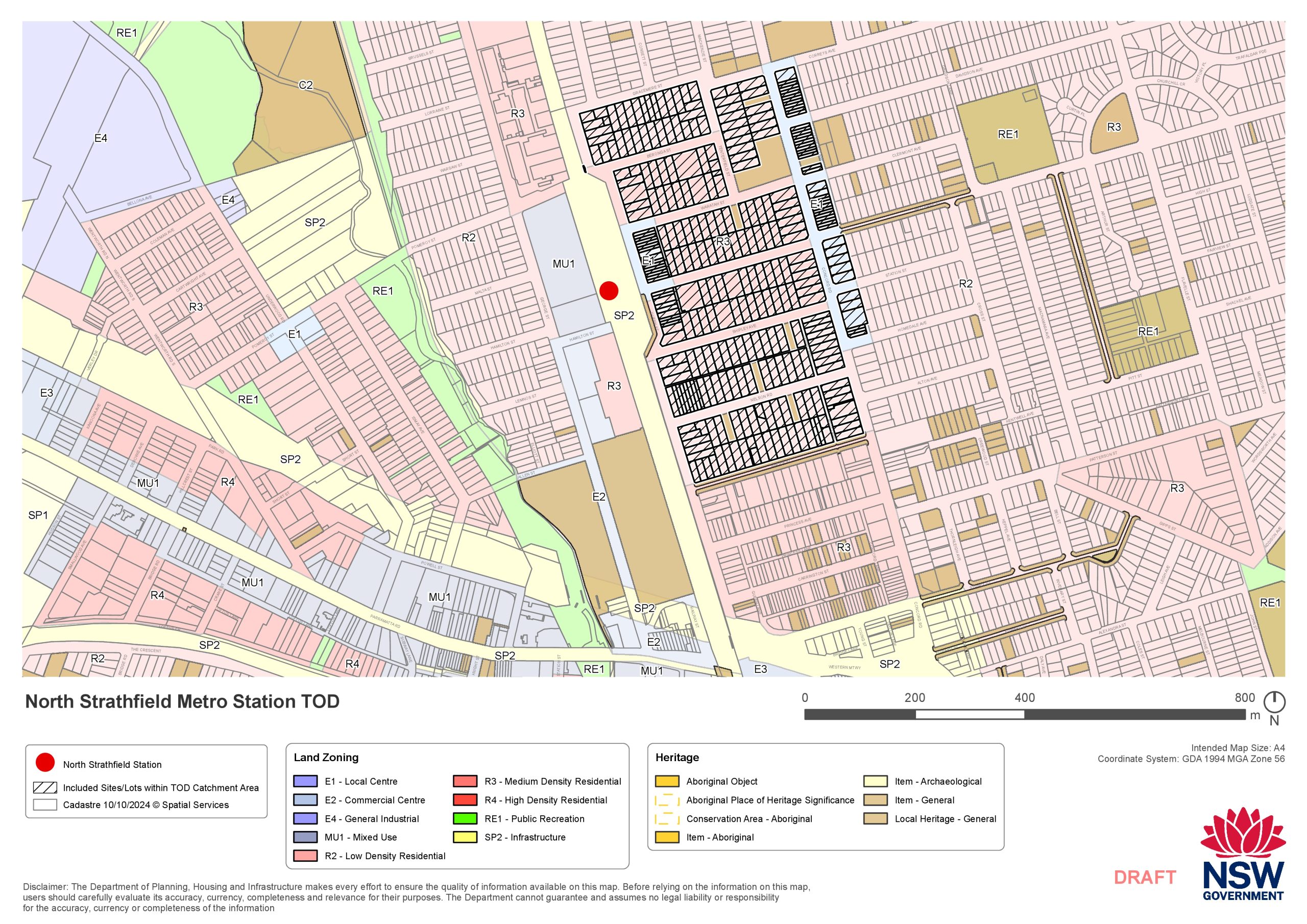
For more details of the North Strathfield TOD, see page 17 of the Canada Bay Council agenda for December 2024.
Next steps:
If you are concerned about this, you can send me an email with your concerns, and/or call me.
Here are my contact details:
Councillor Charles Jago
charles@cejago.com, 0403 902 613