Note that this page is now quite out of date, with information that is now incorrect. For more recent information, go to the 2026 rezoning update.
“If we want a liveable city that isn’t overwhelmed by rows of apartment blocks linked by traffic-jammed private motorways, we must fix the rigged planning system. “Our planning system has little vision for the future, no voice from the community and prioritises profit. It’s time for that to change.”
Senator David Shoebridge
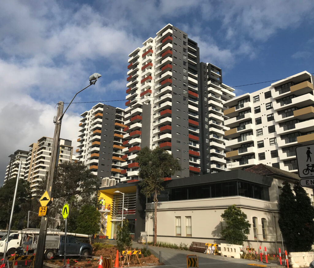
Development is occurring right across Canada Bay, with new rules, new density precincts, duplexes, apartment blocks, boarding houses and more. There are three key levels of program affecting our area:
- NSW Govt changes released in late 2023/ early 2024, which has added extreme density in the poorly located Homebush Precinct, plus relaxed development standards right across our whole LGA, while further centralising NSW government powers away from councils. The Homebush Precinct was rezoned on 27/11/2024.
- Rhodes has now been rezoned by the NSW Government, with an expected population growth in the next ten years of some 65%, heightened by the government’s 30% bonus height offered for 10% to 15% of affordable housing provided for the first 15 years of the building.
- The NSW Government’s Parramatta Road Corridor Urban Transformation Strategy (PRCUTS, issued in 2016) created plans to enormously increase housing density along Parramatta Road from Parramatta to Sydney CBD. Most of the policy changes under this initiative are now complete, and the main area with changes incomplete – Homebush and North Strathfield – has seen those policy changes substantially overtaken by the government’s 2023/2024 programs. However, new approvals and construction in these areas is only just beginning.
NSW Govt changes released 2023 to 2025
The NSW Dept of Planning, Housing and Infrastructure (DPHI) has issued two major changes to planning rules in recent months. (The government describes these as “reforms”; I disagree. A “reform” implies that things have improved.) The changes include:
- The Transit Oriented Development Program (TOD), with two precincts: the Homebush Precinct and North Strathfield Precinct
- Changes to create low and mid-rise housing
- In-fill affordable housing bonus
- Housing Delivery Authority
Areas affected across Canada Bay LGA
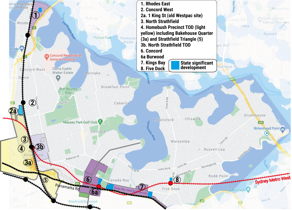
The following map shows areas exposed to higher levels of development.

Areas facing more development
1. Rhodes East
In the area between the railway line and Concord Road north of Mary Street East in Rhodes, the former Liberal NSW Government in 2021 announced plans for 3,600 dwellings in place of the existing ~140 dwellings, plus an additional 600 new dwellings west of the railway line. However, with the “in-fill affordable housing bonus” announced in 2024 by the NSW government, almost all new buildings being built in Rhodes will get the bonus height of 30% for buildings with affordable housing and will consequently be taller. This means the expected population will be even greater – an expected eventual increase of 65% increase above the 2024 population. Note that that affordable housing will only be provided for 15 years – the developer retains ownership, and regains full control after the first 15 years, but the developer keeps the profit windfall.
The government’s transport proposals (including a ferry wharf) are inadequate for current residents’ needs, let alone the future needs of Rhodes and Wentworth Point residents.
2. Concord West
Key issues raised by locals are recurrent flooding and restricted access via George Street, already causing traffic problems.
Recent rezoning of the PRCUTS precinct to the west of Concord West station (strangely called Homebush North) allowing town houses and terrace housing will increase low-rise density over time, while former industrial zones have been rezoned to medium density housing of 5-7 storeys.
The large site at 1 King Street Concord West (previously a Westpac call centre, now vacant) is an exception. It’s now owned by Billbergia, the largest developer in the area, who have submitted a planning proposal for major new development. Of course, it would be a great spot for a new high school.
The owners of 7 Concord Avenue have twice been refused on planning proposals for large residential developments. As of late November 2024, their development application for industrial units on site was before the Land and Environment Court.
3. North Strathfield
Impact of Homebush Precinct TOD
The area north of Bakehouse Quarter on the western side of George Street up to Rothwell Avenue is now part of the Homebush Precinct TOD (Transport Oriented Development program), with huge heights up to 18 storeys from Allen Street up to Rothwell Avenue, based on new zoning finalised in late November 2024. This is the worst place to put very high density.
Next to North Strathfield station, MacDonald College is being zoned out of existence, while no new schools are planned for the area. Based on changes when the zoning was finalised, Our Lady of the Assumption Catholic Primary School (OLA) will now remain. This leaves a huge gap in local infrastructure. The government documents state that high school places are adequate to accommodate the new population – that is ridiculous.
In this area, like Concord West, there is also a significant issue with recurrent flooding there – not helped by Homebush Precinct zoning some areas for significant height in flood zones.
Impact of North Strathfield Precinct TOD
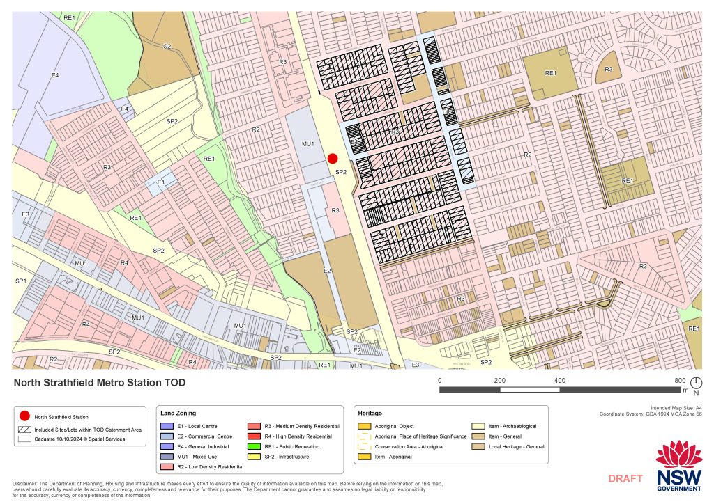
Given the unexpected scale of the Homebush Precinct when the plans were released in July 2024, it then seemed that the North Strathfield Precinct would not proceed. However in late October 2024, the Government announced that it would proceed on the eastern side of North Strathfield station, ie between Queen Street and Concord Road. It was gazetted (ie legally finalised) on 27 November 2024 – the same day as the Homebush Precinct. However, contrary to the government’s own rules, it was never put on public exhibition – the only available detail was a map of the precinct boundaries (below) released the day before it was finalised.

4. Bakehouse Quarter
The Bakehouse Quarter (from around Allen Street down to Parramatta Road) is also part of the Homebush Precinct TOD (Transport Oriented Development program), and now zoned up to 150m (around 45 storeys). Note that the former Arnott’s buildings, protected by heritage, cannot be removed although substantial density will be built all around it. The high scale around the heritage buildings will unfortunately devalue them.
5. Strathfield Triangle
Canada Bay LGA includes an area south of Parramatta Road, extending east from the north-south train line as far as Swan Street, and adjacent to Strathfield Station. All of this area has been targeted for some medium and a lot of high density, with a maximum height of up to 45 storeys. The Strathfield triangle is that part of the area south of Parramatta Road between the train line and Leicester Avenue. It has less open space and fewer services than other parts of Canada Bay LGA.
6. Concord & 7. “Kings Bay”
The Parramatta Road Urban Transformation Strategy (PRCUTS) launched by the NSW government in 2016 included precincts from Granville to Annandale, Within Canada Bay LGA the precincts Concord, Kings Bay and Homebush, each with two phases. Here are the locations:
- Concord precinct from Broughton Street to Loftus Street, up to Burton Street.
- the “Kings Bay” precinct from Walker Street nearly up to Courland Street, up to Queens Road and also sections on Kings Road, excluding Rosebank College and Lucas Gardens School. (Note that all the locals see this area as part of Five Dock – it doesn’t build confidence that the government keeps talking about Kings Bay.)
Both include areas with medium density and high-rise up to around 20 storeys (possibly much more).
Homebush part 2 has been intensified – now the Homebush Precinct of the Transport Oriented Development program.
8. Five Dock (around Great North Road)
While Five Dock has been kept to medium density in areas around Great North Road in the Five Dock CBD, pressure is mounting for greater density due to the new Metro station at Fred Kelly Place. The Metro will also expand Five Dock’s role as a transport hub for buses. Like other centres in Canada Bay, Five Dock will likely be targeted for development under the government’s “Changes to create low and mid-rise housing” program, with those changes yet to be released as of mid-December 2024.
Scale of expected population growth
| Location | Indicative likely population increase |
| Within City of Canada Bay | |
| Parramatta Road Corridor (Stage 1 and 2, excluding Homebush TOD area) | Approx. 20,900 |
| Rhodes East | Approx 10,500 |
| Five Dock Town Centre (this estimate recently revised) | Approx 17,300 |
| Homebush Precinct Accelerated TOD | Approx 26,000 (in Canada bay LGA)(Approx 40,000 in total) |
| North Strathfield TOD | Up to approx. 3,000 |
| Sub total for Canada Bay LGA | Approx 77,700 |
| Adjacent to City of Canada Bay | |
| Burwood North (Burwood LGA, south of Parramatta Road) | Approx. 13,500 |
| Sydney Olympic Park | Approx 21,400 |
| Sub total for adjacent areas | Approx 53,000 |
Source: City of Canada Bay, 14/10/2024
Infrastructure shortfall
Following are some of the main problems now being experienced, which will get worse with the new rezoning of PRCUTS Rhodes and the recent Labor changes.
- Traffic congestion
- Overcrowded trains
- Over-crowded schools: The NSW government has fallen far short in delivering public school places, especially in high schools with long waiting lists. The Sydney Olympic Park High School – promised for 2020 – opened in 2024 – will not be enough.
- Concord Hospital upgrade – upgrades not keeping up. The hospital’s stage 1 upgrades which have just finished in late 2021 were designed to deal with a population increase of 20% over decades. The 2015 stage 1 plan aimed for the hospital to cope with a projected population increase of 20% over 10–15 years based on 2011 census figures. In 2011 the Canada Bay population in was 75,762. Yet the population had already grown by 20% around the start of the project in 2017, and now – at completion – exceeds 30%! See more on the Concord Hospital page…
- Access to open space
- Tree targets in Canada Bay
- Sporting facilities
- Swimming pools
- Libraries
