Note that this page is now quite out of date, with information that is now incorrect. For more recent information, go to the 2026 rezoning update.
New density programs by the NSW government 2023 & 2024
By Councillor Charles Jago
Contents
- New density programs by the government
- The Greens position – we support good development
- Problems with the new changes
- Concerns on these changes across NSW
- Endnote on heritage
The NSW Dept of Planning, Housing and Infrastructure (DPHI) has issued two major changes to planning rules in recent months. These include:
- The Homebush Precinct – Transit Oriented Development Program (TOD)
- The North Strathfield Precinct – Transit Oriented Development Program (TOD)
- Low and mid-rise housing
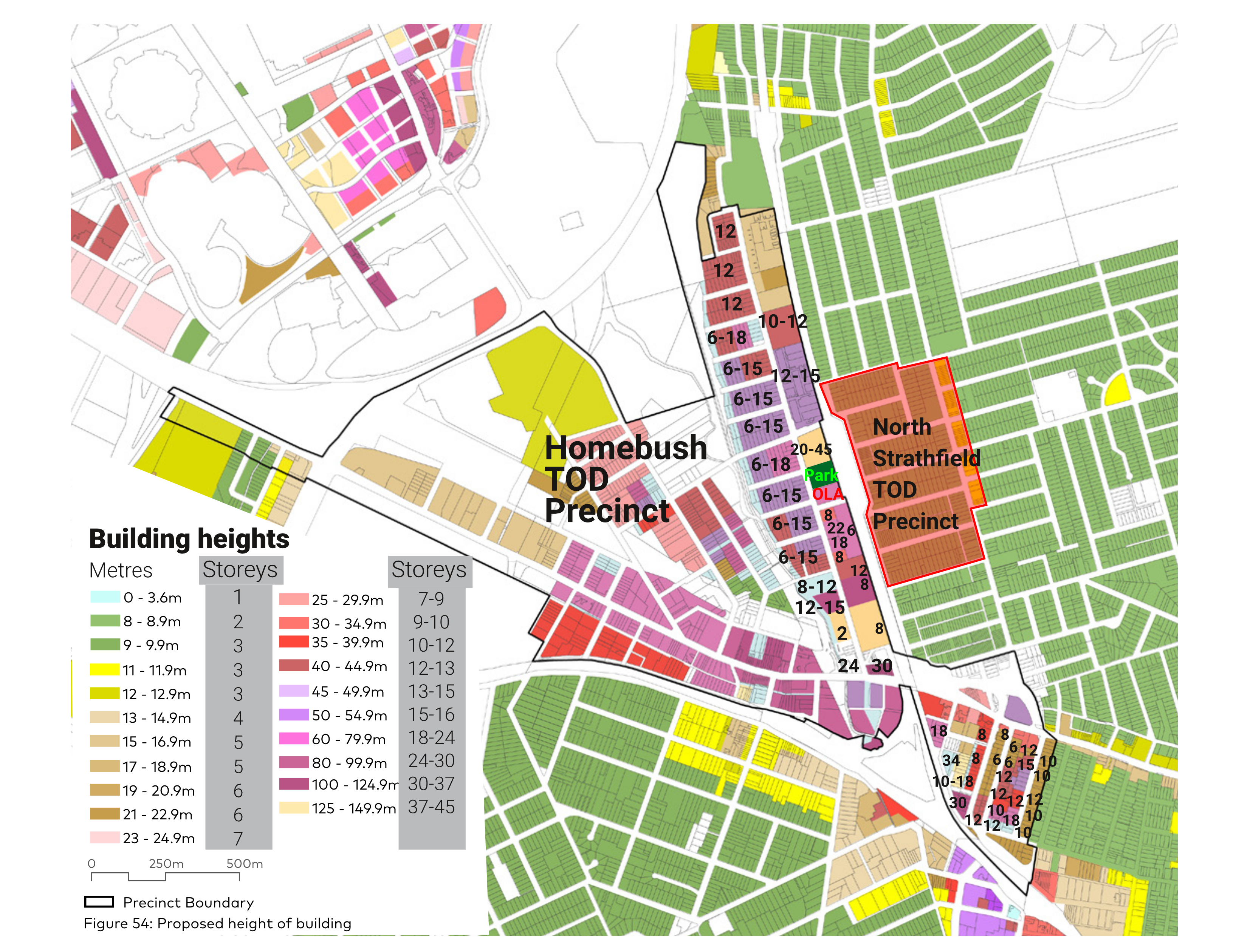
Note: the Homebush Precinct buildings height map above reflects a recent additional height increase by the government in the week that the zoning was finalised. Click either of these maps to see it full size.
Transit Oriented Development Program (TOD)
Initiated in mid-December 2023, the Transit Oriented Development Program aims to put greater density around stations. There are eight “Tier 1” or “accelerated precincts” around metropolitan Sydney, including the Homebush Precinct nominally around Homebush Station. There are 37 “Tier 2” TOD precincts around other stations around a wider area, including the North Strathfield Precinct.
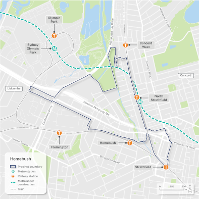
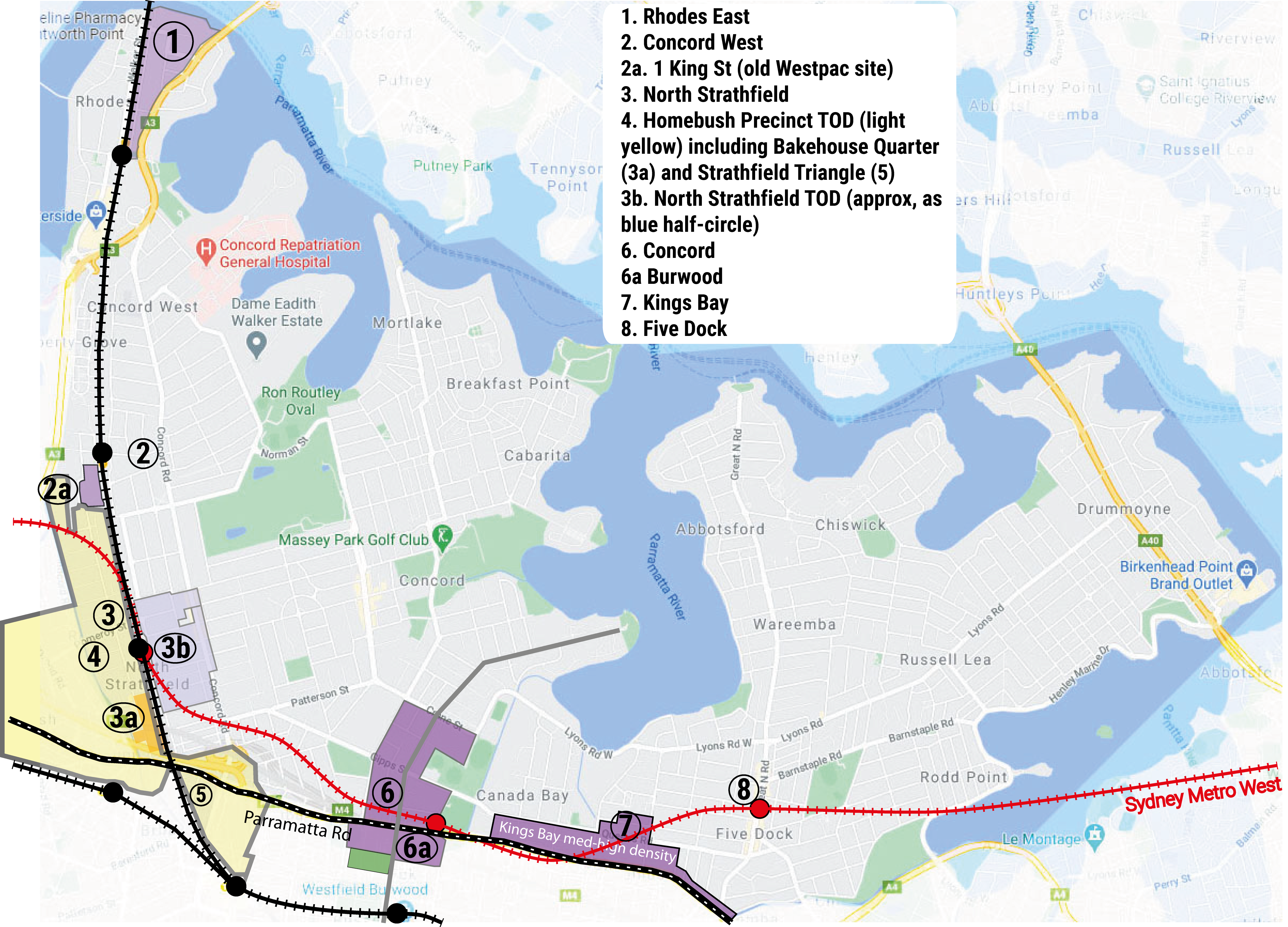
Homebush Precinct TOD
On 27 November 2024, the government finalised the “Homebush Precinct” in parts of Homebush, North Strathfield, Strathfield and Concord West. This area is actually the same as part 2 of the PRCUTS program. See the rezoning proposal finalisation report, the urban design report, the precinct transport statement and the Explanation of Intended Effect documents. See more of the final documents.
The DPHI plan has major problems – see the council response to it, which reveals the full extent of its problems.
One more annoying development: in the last week before it was finalised, the government raised the heights in some areas of the precinct. The maximum height for the Bakehouse Quarter and for the part of McDonald College that has been rezoned has now increased to 150m (45 storeys). The total number of apartments in the Canada Bay part of the Homebush Precinct was increased from 16,100 to 18,300.
North Strathfield Precinct TOD
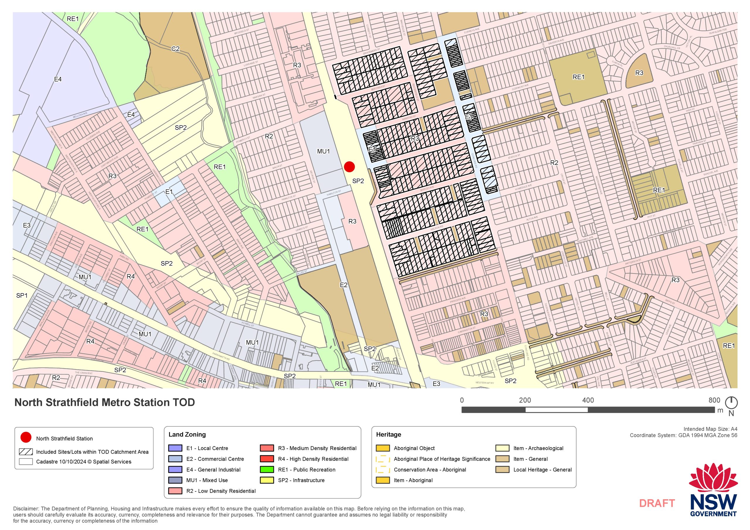
Given the unexpected scale of the Homebush Precinct when the plans were released in July 2024, it then seemed that the North Strathfield Precinct would not proceed. However in late October 2024, the Government announced that it would proceed on the eastern side of North Strathfield station, ie between Queen Street and Concord Road. It was gazetted (ie legally finalised) on 27 November 2024 – the same day as the Homebush Precinct. However, contrary to the government’s own rules, it was never put on public exhibition – the only available detail was a map of the precinct boundaries released the day before it was finalised.
Issues with Homebush Precinct TOD
Large scale
The government’s plans will add around 18,300 apartments bringing approximately another 29,500 people into the North Strathfield and Strathfield triangle areas, plus many more in Strathfield LGA – around 45,500 for the whole precinct. The numbers on the Homebush TOD Precinct map on this page show the maximum building height for each block proposed by the government. With zoning now complete, developers will be looking to identify and purchase sites for redevelopment quickly.
No space allocated for schools or health facilities
Unfortunately, the government’s plan does not allow for sufficient infrastructure. The government’s plan originally didn’t include any space for schools, health facilities or other infrastructure needed for current and future residents, and included loss of two schools – Our Lady of the Assumption Catholic Primary (OLA) and MacDonald College. Now the government has changed the plan to keep OLA, but still zone McDonald College out of existence (it could stay there now but any new site development could only be apartments). The council’s response submission to government noted that the population increase proposed in the government’s plan equate to adding the population from a town the size of Taree, which has two public high schools, five public primary schools, six private schools, three post-secondary institutions and a large hospital. The Homebush Precinct won’t have anything like that. It’s not even sure there is enough retail or other commercial space either.
Unprofessional planning
That’s really bad planning. Given the scale of development proposed, the standard of planning is so poor as to be unprofessional. It is simply essential that planning for any precinct or suburb identify all necessary infrastructure as part of the plan and include space for everything before any rezoning. Now that the apartments are zoned, it will be practically impossible to get the land for the schools and other community needs.
The government is in such a rush that they have implemented a short-sighted, unprofessional plan that will make existing shortfalls worse. While the most serious issue is the total lack of infrastructure, there are also other serious problems in the government’s plan.
Location – extremely constrained by traffic
The NSW government’s Homebush Precinct includes a large area of Strathfield, Homebush, North Strathfield and Concord West, on the Homebush side of the train line, as shown on the map. It runs along George Street from Parramatta Road to Rothwell Avenue Concord West. The main density has been placed along George Street just west of the station, with substantial height and density increases up to Rothwell Avenue. The new zoning is R4 – high density, with maximum proposed heights for each block shown on the map. The Homebush precinct also includes enormous height increases in the Strathfield triangle.
The main problem with this plan is that, on the western side of the train line along George Street, the government’s consultants have picked a highly traffic-constrained location to massively increase traffic density. George Street already grinds to a halt multiple times a day with traffic queues hundreds of metres long. This density goes far beyond any traffic plans ever contemplated for the neighbourhood. Meanwhile, the traffic consultants’ report does not enter into any discussion of why the area was selected [Note – a new version of that traffic report has been released when the rezoning was finalised].
Comment by Charles Jago on the location:
“In the DPHI briefing for Canada Bay councillors on 23 July 2024, I asked why this area had been selected, when the traffic in it was so much greater than surrounding alternative areas. I mentioned that I had recently witnessed a buildup of cars along George Street stretching from Pomeroy Street nearly to Argonne Street – around 4.5 blocks.
“The response from DPHI staff was that this area was selected because it was previously selected for PRCUTS. There had clearly been no comparison of alternative areas to put the greater density. This means that the DPHI statement on selection criteria is wrong. And in any case, anybody living anywhere along George Street North Strathfield can tell you that the local constraints make it a worse proposition than other options.
“This represents a major problem for the area, with intensification of traffic far greater than it would have been if a more suitable site had been chosen.”
Area of increased density
Low and mid-rise housing
DPHI released the Changes to create low and mid-rise housing with an “explanation of intended effect” (EIE) document in mid-December 2023 for land within:
- 800m walking distance of heavy rail, light rail or metro stations;
- 800m walking distance of land zoned E2 Commercial Centre; and
- 800m walking distance of land zoned E1 Local Centre or MU1 Mixed Use, but only if the zone contains a wide range of frequently needed goods and services, such as full-line supermarkets, shops and restaurants.
Unlike the TOD program, the changes vary with current zoning. Where medium-rise zoning (R3 Medium Density Residential) is already in place, the proposed changes will allow 6-storey apartments within 400m of stations or centres, and 4-storey apartments for areas from 400m to 800m of these locations. The changes will also allow “shop top housing” (one or more dwellings located above a ground floor commercial premises or health services facility).
The NSW Government also wants to allow multi dwelling housing in low density residential zones (R2) within station and town centre precincts – this includes townhouses, terraces and manor houses, in addition to dual occupancies which are already allowed. The government has created “non-refusal standards” for all of these with larger heights and floor space ratios and smaller site width and site area requirements than currently exist. These buildings will be inappropriately sized for the area, but council won’t be able to stop it.
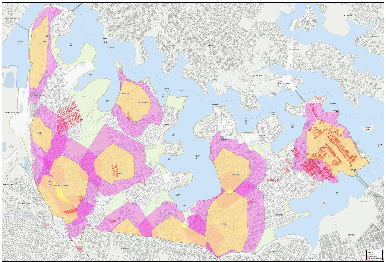
These changes are far-reaching across Canada Bay LGA and there is some uncertainty about which areas will be actually included. Depending on how the centres are chosen, these new rules could apply to the majority of Canada Bay LGA. Please refer to the map below. Despite the uncertainties, these changes are already being made legal in stages starting on 1 July 2024. The first stage permits dual occupancies and semi-detached homes in all R2 low-density residential zones across NSW.
In particular, there are three local centres with E1 zoning (small commercial centres, surrounded by residential zoning) which could be affected: Concord West, Mortlake and Wareemba. Council staff have recommended (and the Canada Bay Greens agree) that four storey to six storey developments, plus town houses and manor houses (two storey apartment blocks usually with just four apartments) should not go in these areas, because it is inconsistent with the existing and desired future character of these places. That’s why the council’s planning staff specifically recommended removing E1-zoned centres from the changes. Note that Concord West is still affected because the rules apply around stations as well.
In addition, the changes will also have irreversible impact on heritage protected places (see endnote), with no apparent pre-analysis on the likely effects. Numerous historical places will be lost if this goes ahead.
With these changes to housing around many residential centres, the government is making changes to an area far larger than necessary to meet their housing goals. With the substantial height increases the government is requiring, they could have limited the changes to a smaller area and still achieved a huge number of additional dwellings. The broad geographical extent of the planning rules means that the majority of established suburbs across Canada Bay LGA will be irrevocably altered over time.
In addition, DPHI has recently expanded the incentives potentially available to developers for affordable housing with extra building height and floor area. However, affordable housing has been diluted to only last for 15 years.
See the council’s responses to the “Changes to create low and mid-rise housing” program and the related new “Housing SEPP” (SEPP – State Environmental Planning Policy).
Map of combined changes
The map below reflects the July 2024 release of the NSW government’s TOD changes (above); note that some smaller changes have not yet been included.
The Greens position – we support good development
The Canada Bay Greens support additional well-planned medium density housing in Sydney, where it can integrate into the existing location, infrastructure, architecture and heritage of the local area. We support “building up, not out” – because the alternative is cutting down forests including koala habitat on the outskirts of Sydney and converting farmland into urban sprawl. In principle, locations around stations and other areas are places where additional housing makes sense. We oppose more high-rise in suburban areas due to its capital and maintenance expense, its traffic impacts and other issues. See more…
Problems with the new changes
The major problems include:
- Undermining local government’s role in land use planning undertaken in consultation with the local community.
- Around 80% of Canada Bay’s heritage housing put at risk (see endnote).
- A substantial reduction in the extent of new affordable housing in Canada Bay.
- Greater loss of trees, making it impossible to meet the council’s tree canopy target of 25% by 2040.
- Degrading the quality of new housing developments by removing rules for good development.
For a more detailed explanation of the problems of these changes see Government over-reach on housing – let council do it properly (about Canada Bay Council’s motion on this), Canada Bay Council’s description of the changes or (more broadly) a quick guide from Greens NSW.
What must be done:
- There must be sufficient infrastructure, especially including green space, public transport, good transport access and public schools to meet the needs of the increased population. Right now, the current infrastructure is inadequate for the needs of the population we have today.
- The rules must ensure good quality development using accepted planning standards and not arbitrarily undermine the environment or heritage. The proposed rules for apartments don’t specify a minimum plot area or minimum frontage for new apartments, which will encourage 6 to 9 storey apartments next to single family houses – that’s bad planning.
- A part of each development must be provided to the council as permanent affordable housing, at a proportion at least similar to existing council affordable housing programs (currently 4% or 5%).
- There must be proper engagement with the community and local government.
Unfortunately, the new programs have major problems when considering the concerns given above. However, Canada Bay Council (and also the Greens) would like to work with the government to properly implement additional housing, because new housing is urgently needed.
Will the government plan work?
More broadly, the success of the government’s plans is in serious doubt. The government is desperately hoping that, with so much rezoning, developers will flood the market with new housing. However developers already have plenty of rezoned properties that they can develop, as councils across Australia have approved record levels of housing in the last ten years. In order to ensure premium profits, developers will continue to avoid flooding the market.
It’s now clear that the private sector won’t build the scale of housing we need. That’s why in Australia after World War 2, governments – federal and state – stepped up and directly developed the housing themselves. That’s what we need now.
The changes wipe out protection for heritage listed places in the areas where they apply (see endnote), undermine existing programs of affordable housing, and erode design quality controls. Meanwhile the government is not offering any additional improvements to infrastructure or services in the area, although there is a fund of $520 million shared amongst the 8 accelerated precincts across Greater Sydney for improved roads, transport links and parks – which won’t go very far at all.
See the Council’s official response to these changes, in their submission to DPHI.
Feedback on these changes across NSW
Other councils’ concerns
- Northern Beaches Council: Radical state planning changes to create medium and higher density housing …”Proposed amendments to State Environmental Planning Policy (Housing) 2021 would override all NSW councils’ planning controls and restrict a local council’s capacity to refuse inappropriate development. The implications of the proposed policy are alarming for the Northern Beaches, our community and the environment.”
- Ku-ring-gai Council …”There will be impacts on heritage, trees, biodiversity, traffic and stormwater. Significant tree loss across Ku-ring-gai. No consideration currently given to the necessary infrastructure to support density such as schools, transport and community facilities.”
Local Government NSW
Key concerns surround Government’s housing supply changes “… the process disregards the carefully considered strategic planning work undertaken by councils in consultation with their communities and the Department to deliver agreed housing targets tailored to the characteristics and capacity of different places.“
Better planning network
“… extensive damage to the environment, loss of heritage, and overload infrastructure and local services.” See more…