By Councillor Charles Jago, updated January 2026
On this page:
- Government “Low and medium rise housing” changes
- State Significant Development (SSD)
- Affordable Housing bonus
- Notes on current developments
- Other notes on development applications (DAs) and planning proposals.
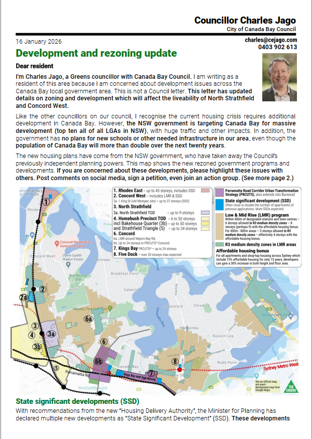
This page covers Information about recent NSW government plans for greater housing density. There are multiple government proposals. I support well-planned new medium density housing in Canada Bay LGA – “building up, not out” – because the alternative is cutting down forests including koala habitat on the outskirts of Sydney and converting farmland into urban sprawl. In 2024 I distributed a letter to Concord West residents outlining some of the government’s proposals and raising my concerns about them. In January 2026 I am now distributing a new letter to residents with updated changes.
“Low and medium rise housing” (LMR)
Introduced in 2025, the NSW government rules allow increased density within 800 metres of a railway station and some shopping centres. In medium density (R3) zones – shown in blue-green on the map – those changes allow greater height to apartment blocks, with six storeys allowed within 400m and three storeys within 800m. In low density residential zones, they allow more duplexes, terraces, town houses and single-block, two-storey apartment buildings (called “manor houses”). The council can’t change these NSW government policies.
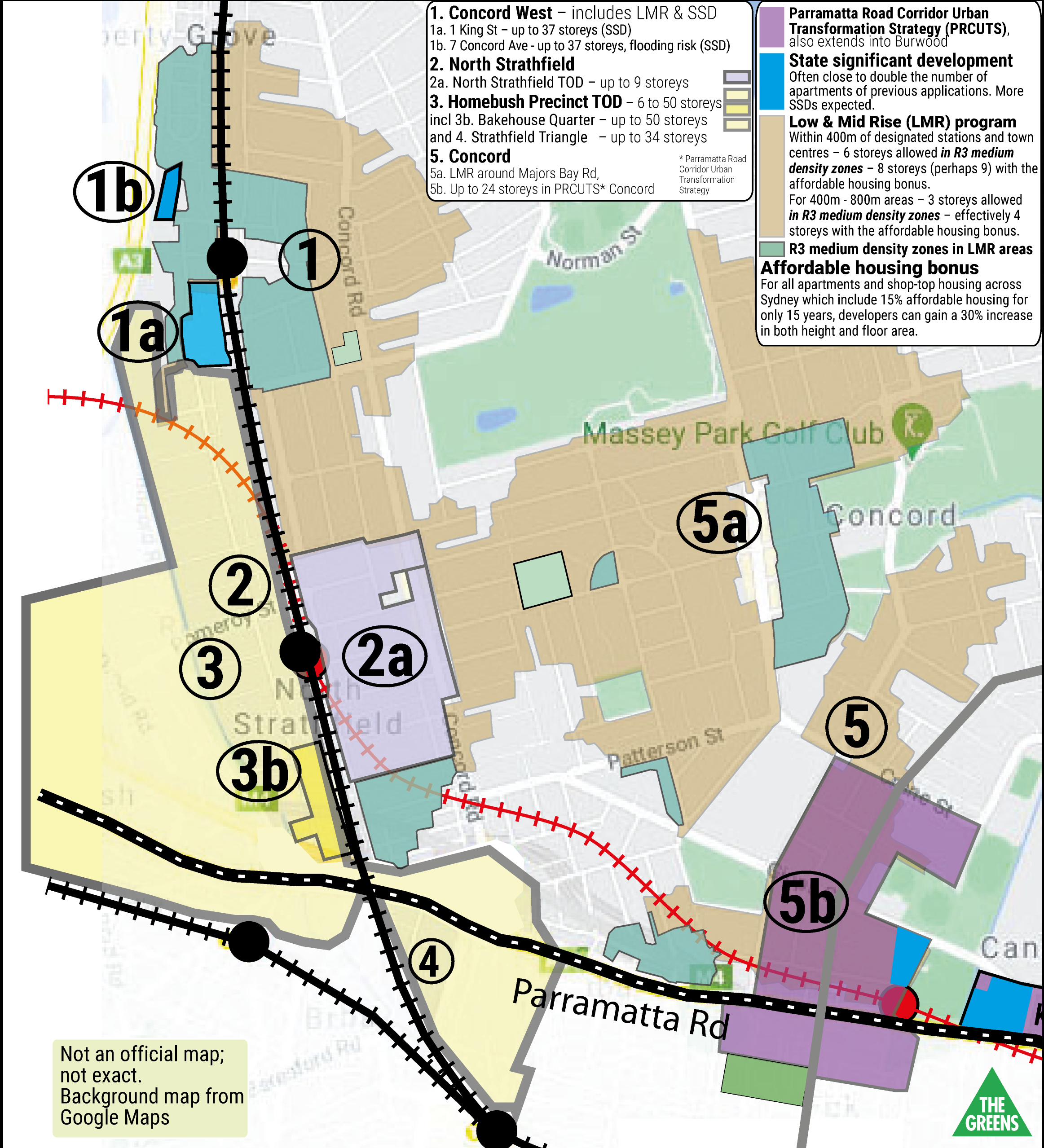
LMR in residential areas allows terraces, townhouses and two-storey apartment blocks near transport hubs and town centres up to 800m from the station. This is shown on the map in light brown.
LMR in medium density areas allows apartments in R3 zones to be taller, shown in blue-green on the map. Six storey apartments (8 or perhaps 9 storeys using the new Housing Affordability bonus – see below) are now allowed up to 400m from the station. Between 400m and 800m from the station in R3 areas, LMR allows three storey apartments (4 storeys using the Housing Affordability bonus).
Affordable housing bonus
For all apartments and shop-top housing across Sydney which include 10% to 15% affordable housing for only 15 years, developers can gain a 20% to 30% increase in both height and floor area.
State Significant Development (SSD)
With recommendations from the new “Housing Delivery Authority”, the Minister for Planning has declared multiple new developments as “State Significant Development” (SSD). These developments bypass Council and regional planning panels with all zoning and approvals handled by the Department of Planning. Current SSDs are shown on the map, with more to come. Key local SSD developments in Concord West include 1 King Street and 7 Concord Avenue. Declaring these as SSD has more or less doubled their size.
Make a submission on the 1 King Street development before 2 February 2026– mixed Use Development (SSD-81999457). You can also connect on Facebook to the development action group led by Joanna Somerville (Canada Bay Greens) and Louise Lin
See a list of SSDs in Canada Bay LGA, or see information on more recent SSDs. (For those with long memories, this is the old “Part 3A” system for ministerial approval of large projects.)
Dealing with change in your area
Rezoning does not force anybody to sell their property. Staying or selling is entirely up to you. However, some owners might sell to take advantage of increased housing values. For information, talk to your neighbours and get legal and real estate advice from experts you trust. You can also call Council to get factual information about zoning in your area. Also look at the Department of Planning Spatial Portal to check on zoning of any property.
Impacts of the changes
Like most people, I want to see the housing crisis resolved. However, I have strong doubts that these changes will actually increase housing supply for those who are struggling to afford it, without a substantial government commitment to more social and affordable housing and improvements for renters.
The problem for the community is that the government’s rezoning will impact the liveability and amenity of our area. But it is too late to get any significant changes on these new rules, and the government isn’t listening. Despite public criticism, the government’s rezoning will bring more developments anyway.
The main focus of community action should now be to
- reduce the worst aspects of the worst developments (ie 1 King Street and 7 Concord Avenue in Concord West) and to
- lobby regarding the huge gaps in infrastructure the community is facing.
The key infrastructure issues include:
- Excessive building heights of 1 King Street and 7 Concord Avenue will impact local amenity.
- Catastrophic effect on traffic of an additional 1,468 cars proposed by King Street development, plus7 Concord Ave, and other developments – more infrastructure needed in public transport and roads.
- No additional childcare, primary or secondary schools (except the new Rhodes primary) for additional residents in or close to this area, plus the loss of MacDonald College expected within five years. The NSW government must fund and expedite schools –especially a new public high school.
- No plans to upgrade train passenger capacity for Rhodes, Concord West and North Strathfield – over capacity since 2015.
- Inadequate consideration of existing open space and impact of climate change.
What you can do
- Please sign my petitions calling for liveable development and a major upgrade for the T9 Northern train line.
- Join and raise the issue on existing community news groups
- Join the Concord West & North Strathfield Locals Against Overdevelopment Facebook group.
- Write emails or letters to state and federal MPs, Stephanie Di Pasqua MLA and Sally Sitou MP.
Notes on current developments
As of 21st January 2026.
1 King Street, Concord West (old Westpac site)
This site has been declared State Significant Development, and is now on public exhibition with a proposed 1400 apartments (up from ~600 previously). It has 8 buildings, 6–37 storeys in height, mixed residential, retail and commercial. Make a submission before 2 February 2026– mixed Use Development (SSD-81999457). You can also connect on Facebook to the development action group led by Joanna Somerville (Canada Bay Greens) and Louise Lin.
Please see my guidelines for help in objecting to development to assist in your responses.
7 Concord Avenue, Concord West (Paintball/Go Kart site – flood zone)
This development, twice refused before because of flooding danger to residents, has been declared as SSD at even greater height with 1,300 apartments in 7 buildings from 10 to 40 storeys. The SSD application is expected to be submitted to DPHI by mid-2026.
25 George Street, North Strathfield
The developer received approval to add 3 storeys to the front building and one storey to each of the two back buildings, amounting to an additional 41 apartments and a new total of 186 apartments, as a 30% bonus based on providing affordable housing for 15 years under the government’s new rules.
Other notes on development applications (DAs) and planning proposals
A development application (DA) is an application for demolition, construction or renovation under existing zoning, submitted by or on behalf of an owner. It could also be a request to allow the usage of the building to be changed, eg. from residential to business use.
A planning proposal is a document that requests permission to amend the Local Environmental Plan (LEP), the council’s key planning document. The planning proposal may be a request to alter land uses through rezoning and/or amend the development standards, such as height of building, floor space ratio, heritage, additional permitted uses, or other clauses. A planning proposal is the first step in making an amendment to the LEP through the Department of Planning and Environment Gateway Process.
Council staff receive and report on all DAs and planning proposals.
Contested DAs (eg at least ten unique objections) are determined by the “Local Planning Panel”, which deals with Canada Bay DAs but is not actually local, because it is composed mostly of people recruited by the NSW Government and works to rules determined entirely by the NSW government. Their decisions are based on whether a development follows the government rules, not the actual merit of the development.
DAs valued at over $30 million go from staff to the Eastern Planning Panel.
All planning proposals are determined by councillors, with accepted planning proposals going to the government who can then veto or change them. Proponents of planning proposals rejected by Canada Bay Council can still take their planning proposal to the Eastern Planning Panel, who may accept it with whatever changes they wish to make.
Related links
Huge planning rules changes will create problems across Canada Bay LGA